
I set out to trace paths that once linked an empire. I walked old stretches of road near Rome to see how these lines shaped travel, trade, and power from about 300 BC onward.
The network of highways and local links once radiated from the capital, giving people a fast, reliable way to move armies, goods, and messages across the world.
On short day hikes I followed named routes like the Via Appia and lesser-known alignments such as the Via Latina and Via Salaria. Some sections still reveal stone paving; others hide under modern surfaces.
I balance practical advice and historical context so a half-day outing feels both safe and meaningful. I note surfaces, simple loops, and where milestones, bridges, and villas make the walk feel alive underfoot.
Key Takeaways
- These short routes make imperial history easy to experience in a day.
- Many segments still show original paving, milestones, and bridges.
- I highlight accessible loops within reach of central Rome.
- Understanding viae categories helped me pick authentic routes.
- Expect a mix of stone, gravel, and modern surfaces on walks.
Why I seek out forgotten Roman roads on day hikes near the city
I seek out old paved corridors near the city to feel the span of centuries underfoot. Walking short segments compresses time so design choices become tangible: camber that sheds water, side ditches, and cut stone that still holds a line.
The engineered route often follows a surveyed course, with sections bridged or raised on piles over marshy ground. Those visible features make a half-day outing feel like a field lesson in ancient technique rather than a long trek.
I prefer linear walks where each bend explains a decision — why a road shifts, where a causeway crosses a stream, and how paving resists wear. I use quiet back lanes and park corridors that trace these alignments, picking safer shoulders and clear pedestrian ways.
The rhythm of following a single corridor is meditative. My aim is not to reach a summit but to read a segment from gate to milestone. Public transport, light gear, and clear wayfinding make these routes ideal for casual half-day exploration.
How Rome’s road network shaped the routes I walk today
The layout I follow today reflects laws and funding decisions set centuries ago. I plan each short hike with those layers in mind so a line of stones tells a civic story.
From viae publicae to viae vicinales: what the categories mean for hikers
Ulpian divided ways into three types. I look for the main, well-built lines where the viae publicae once ran; these were the backbone and often keep visible paving.
Smaller connectors, the viae vicinales, are where I find quiet stretches into fields. They often feel more rural and offer safe, low-traffic detours.
Public expense, local maintenance: who built and cared for these ways
The maintenance system used curatores and contractors for primary upkeep. Magistri pagorum oversaw neighborhood work and could require local labor.
- I favor major roads for clear alignments and surviving milestones.
- I treat vicinales as scenic spurs that reveal local texture.
- Where local upkeep lapsed, I expect gaps and plan alternate lanes or park paths.
| Type | Who cared for it | Hiker clue |
|---|---|---|
| viae publicae | Curatores, contractors (public expense) | Stone paving, milestones |
| viae privatae | Landowners, could be opened to public | Field tracks, uneven surfacing |
| viae vicinales | Magistri pagorum, local labor | Quiet lanes, rural connectors |
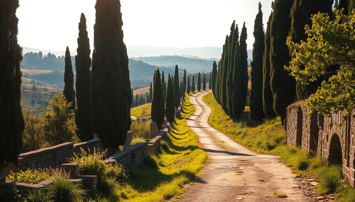
My essential short day route on the Appian Way (Via Appia Antica)
I start at Porta San Sebastiano and take the Appian’s first miles, where engineered lines and funerary architecture meet. Walking this short stretch gives me visible clues to past construction and how the route linked cities and estates.
The first miles from Porta San Sebastiano: stones, milestones, and villas
Along the initial mile I watch for milestones and villa ruins set back from the carriageway. The old basalt stones show polygonal joints in places, and I pause to photograph tomb facades.
Safety, surfaces, and where the original basalt blocks remain
The surface alternates between original basalt blocks and modern overlays. I keep to the crepido or verge where possible and pick quieter morning hours to avoid bikes and service traffic.
Optional loop: catacombs and countryside lanes off the main road
A short spur to San Sebastiano and San Callisto makes a neat loop. Country lanes rejoin the Appian after light-traffic stretches, so wayfinding stays straightforward if you carry a map.
- I point out the best places to read camber, edge stones, and drainage ditches.
- Photo stops at villas reveal why this road linked cities and landed estates.
Quiet spurs and viae vicinales off the Appian Way I love exploring
I’ve learned to spot an ancient line where a hedgerow, a ditch, and a straight sightline meet. Small spurs that leave the Appian often head into fields and village lanes. These paths reveal how old corridors threaded between built-up streets and open land.
Reading layers of time where streets meet fields
I map short out-and-back detours that start on the main road and vanish into farm lanes. Within minutes the noise drops and the route feels older.
- I traced several spurs that follow a clear alignment beneath modern asphalt.
- Boundary walls and reused stone in culverts show local repair and reuse by magistri pagorum and landowners.
- The camber and gradient often survive even where paving does not, confirming the course.
| Feature | How I spot it | Why it matters |
|---|---|---|
| Alignment | Straight sightlines, hedgerows | Shows planned route across fields |
| Reused stone | Field walls, culverts | Local repair links to historic maintenance |
| Camber/gradient | Raised profile, drained edges | Confirms the route despite surface change |
Forgotten roman roads: short walks along Via Latina, Via Nomentana, and Via Salaria
I map short stretches where urban pavement fades and ancient alignments reappear in parkland. These half-day walks show how early tracks became main roads that linked Rome to nearby towns.
Via Latina Park segment: a clear path moves from city edge to green corridor in under a day. I walk 4–7 miles out-and-back, noting where the surface shifts and where milestones or reused blocks hint at earlier work.
Following the Nomentana: beyond the walls I trace straight property lines and old masonry. A few culverts and a shallow bridge site confirm a line that Livy and later sources associate with early expansion.
Salaria river approach: I hug the river margins to spot likely bridge points and surviving blocks. The trade logic is obvious here: the corridor kept traffic moving and shows engineering choices at gradients up to 10–12%.
Check park maps and municipal path networks before you go. They often preserve route legibility where paving has vanished.
“Short loops reveal how these major roads threaded city and countryside.”
What “straight” really means: navigating Roman alignments on modern maps
I begin by locating ruler-straight segments on satellite view, then check where those lines step aside for hills or streams.
Straight for me is not an unbroken line but a section-by-section alignment. Long, linear stretches can run for many miles, then pivot where terrain demands. That pattern is a key clue on maps.
I use cadastral boundaries, long hedgerows, and uninterrupted parcel lines to reconstruct a likely route where modern streets curve away. Measuring distance between bends helps confirm consistent bearings.
Drainage logic matters: builders favored ridgelines and dry shoulders. On the ground I look for subtle camber and raised verges that match the mapped line.
- Toggle satellite and street layers to reveal faint trackways.
- Plot straight sections, then mark pivots where slopes rise sharply.
- Use small field checks for shoulder height and camber to confirm the mapped line.
“Section-by-section alignments create a steady rhythm for walking: long, straight strides followed by a deliberate shift to meet the land.”
How the Romans built these roads—and how I spot authentic fabric
A quick inspection of an exposed verge usually reveals the road’s true makeup. I look for a clear stack of layers and small clues at cuts, burrows, or eroded shoulders.
Five-layer anatomy helps me read a section in seconds.
Five-layer anatomy: statumen, rudus/audits, nucleus, agger, and edge stones
Statumen sits on leveled earth: fist-sized stones that peek through where the top has worn away. That hint alone often proves age and original construction.
Rudus or audits is a broken-stone mix with lime that binds the middle course. Above that the nucleus is a fine, compact bedding of small fragments and mortar; I’ve seen it exposed at road cuts and in embankment burrows.
The surface uses fitted basalt blocks or rectangular stone slabs. Edge stones and a surviving crepido often form a single surviving course where the rest was robbed for reuse.
Camber, drainage ditches, and why sections feel raised underfoot
I pay attention to a slight crown in the center—camber—and the parallel ditches that carry water away. These features make sections feel raised and keep feet drier after rain.
- I test verges for statumen by noticing fist-sized stones at eroded edges.
- Tight polygonal joints and polish on high spots signal authentic surface wear.
- I check tooling marks and joint irregularity to distinguish original fabric from modern restoration.
Practical note: construction details affect walking comfort. On uneven blocks I tighten laces and slow my pace. Where the surface is reconstructed, steps feel smoother and my ankle strain drops.
Short countryside day route: remnants along the Via Labicana and Gabina corridor
I trace a short half-day line where the Via Labicana (first noted 421 BC) meets traces of the older Via Gabiana (circa 500 BC). The paths began as leveled earthen tracks before later paving, and they still sit in the open land between hamlets.
My route follows straight field edges, low ridges, and public footpaths that cross the old alignment. These markers keep the walk simple and easy to reverse if needed.
I look for subtle embankments, drainage traces, and reused masonry in walls. Those signs reveal where viae survive beneath later layers and farm tracks.
Compared with the Appian’s basalt, surfaces here are mostly earth and gravel. Raised profiles stay drier after rain, but some farm lanes become muddy and slippery.
Access is simple: step in where municipal paths meet the line and plan an exit at a bus stop or village link. I carry a printed map overlay to stay confident when tilled fields erase visual cues.
“A short corridor walk shows how diverse the roads roman network could be—engineered in parts, field-tracked in others.”
- Half-day loop: straight ridges and field edges guide the way.
- Vestiges: embankments and reused blocks mark the old course.
- Seasonal tip: avoid low farm tracks after heavy rain.
Walking secondary roads (viae privatae and vicinales): small ways with big stories
I often slip off main tracks to follow faint farm lanes that once served villas and hamlets.
Estate tracks that became public ways over the years
Many estate lanes began as private drives and, by use, became accessible to neighbors and traders. These viae privatae can connect a villa to a larger route and, over generations, act like a minor public high link.
Viae vicinales served villages and fed larger arteries. They feel quieter and show different surfaces — from compacted earth to firm gravel, sometimes labeled historically as viae glareae.
When I walk these stretches I look for clues: continuous farm entrances, old parish boundaries, and worn wheel ruts. These hints tell me a small route once handled supply runs and market trips.
- Identify continuity between gates and lanes to spot former private links.
- Expect surface change — adjust shoes and pace for gravel or soft earth.
- Respect fences and use established rights-of-way where they exist.
- Pair a secondary stretch with a main road section to compare engineering standards.
“These small tracks reveal the supply chains and daily travel that supported larger routes.”
Roman laws, widths, and wayfinding: what the Twelve Tables tell my feet today
I use ancient width rules as a measuring stick to tell a true public street from a farm track.
The Twelve Tables set clear standards: a public road must be eight Roman feet across on straight stretches, and twice that where it curved. Later rural routes often measured about twelve feet so two four-foot carts could pass with room for walkers.
Those numbers help me on the ground. A steady breadth, paired with edge stones or a paved verge, signals a public line rather than a casual path. Where width and pavement survive, I read public status in the fabric itself.
The law also allowed passage over private land when a road fell to disrepair. That idea survives in modern easements and explains why some historic lines remain walkable near the city. Romans limited wheeled traffic in urban cores; echoes of those rules show up as pedestrian-priority zones near gates today.
- I look for consistent width, pavements, and edge stones to confirm public status.
- I respect current rules and private property, even where ancient rights once applied.
- Public expense for major works often meant better stonework near temples and civic streets.
From soldiers to salesmen: imagining a cart’s journey while I hike
I walk and imagine the corridor filled with movers: soldiers, officials, traders, and local people sharing a clear line across the land.
That mental picture shapes how I read each mile and each crossing.
Why goods, people, and official messages moved fast on these routes
I narrate a mental journey alongside my steps, picturing a loaded cart keeping to the smooth center while runners or riders passed at the verge.
Straight sections and neat junctions made it easy to plan a trip without doubling back, a key efficiency in the highways network.
- I note milestones and bridges as signals that the way was meant for steady travel and timing.
- I picture a cart choosing the smoothest paved stretch; that choice mirrors my route picks for comfort and safety.
- Secondary links reduced detours between market towns, just as I use side lanes to craft short loops.
- Thinking about itineraries—like traders in Britain combining main routes to avoid backtracking—helps me map probable lines on the ground.
“Imagining the journey brings every bridge, milestone, and rise to life; each pause becomes a logbook entry for the past.”
| Feature | Why it mattered | How I use it on a walk |
|---|---|---|
| Milestones | Marked distance and official routing | Confirm a likely corridor and timing |
| Bridges | Kept carts moving over rivers and gullies | Serve as natural photo and rest points |
| Smooth surface | Lowered wear on wheels and feet | I pick those stretches for faster, safer walking |
Reading the landscape: milestones, bridges, and reconstructed stretches near Rome
I watch mile markers for the small headlines they are—names, numbers, and repairs that map an old itinerary. Milestones often tell me how many miles lay to nearby cities and which curator or emperor paid for work. A carved name or date gives context that a bare path cannot.
Bridges are another clear clue. Even when a span has been rebuilt, abutments and approach ramps reveal the original road line and how engineers crossed streams.
Reconstructed stretches in parks help me visualise original blocks and camber. I note which restorations match known construction and which are modern interpretations.
I combine inscriptions, map overlays, and what I see on the ground to confirm a corridor where modern development obscures an alignment. That cross-check keeps my route reading honest.
- I read milestones to estimate miles and identify restorers.
- I look for bridge abutments, raised embankments, camber, and ditches.
- I compare reconstructed surfaces with surviving paving to judge accuracy.
- I photograph camber and edge stones for later study and reference.
- I pace out distances between markers to feel ancient measurement in my steps.
“On the ground, inscriptions and surviving fabric make the century-long plan readable, step by step.”
Respecting ancient layers: preservation etiquette on fragile stone and soil
Each fragile stretch demands careful use so later visitors can read the land. I treat exposed surfaces as an archive, and I plan every step to limit damage.
Many surviving sections were built to last but are now thin or partly reconstructed. Edge stones, side pavements, and ditches protect the main carriageway. Trampling beyond the intended tread can crush compacted layers and harm archaeological context.
My practical rules:
- I follow established treads and avoid stepping on exposed courses or verge edges where stone or compacted fill shows.
- I respect signs and barriers — conservation work may use modern materials to stabilise a section.
- I walk in small groups on narrow stretches and keep dogs leashed to protect soil and drainage features.
- I leave blocks, sherds, and loose finds in place for researchers and future walkers.
- I wear soft-soled shoes to reduce scuffing and improve grip without grinding the surface.
“Careful footsteps are the simplest way to keep these lines readable for the next visitor.”
Planning tips for Americans: time of day, gear, and transport for these routes
Finding a good start point near a city gate often decides whether a morning walk feels like discovery or a scramble. I build a short plan that fits transit times, light, and surface conditions so the half-day feels smooth.
Bus, bike, or on foot: reaching trailheads from central Rome
I use local buses to reach gates such as Porta San Sebastiano, then continue on foot or by rental bike. Many historic courses sit within a mile of old gates and are easy to access from central hubs.

Shoes, water, sun, and stone: practical prep for a half-day
I recommend starting early to enjoy cooler temperatures today and lighter foot and bike traffic on popular segments. Roman-era rules once limited carts near walls during daylight; modern pedestrian zones keep many stretches calm.
- Footwear: supportive shoes for stone and gravel.
- Sun & water: sunscreen, hat, and at least 1 liter for a 3–4 hour route.
- Transit tips: treat the outing like a day trip from New York—check bus timetables and plan simple out-and-back ways to reduce navigation stress.
- Maps: save offline maps and mark return stops; clear linearity makes wayfinding easy even if service drops.
“Start early, travel light, and let transit shape the plan—this makes a short corridor walk reliable and rewarding.”
| Item | Why | Quick action |
|---|---|---|
| Park hours | Some sites close or have service interruptions | Check municipal maps and notices |
| Crepido (sidewalks) | Safer pedestrian edges | Keep to verges where present |
| Flexible stops | Weather and footing change | Plan optional photo/rest points |
Conclusion
A half-day on these tracks connects millennia of maintenance and travel in a single afternoon. I feel how straight surveying, layered construction, and a tiered maintenance system shaped routes that still guide movement today.
I find that short walks make technical detail readable and meaningful. Understanding categories, fabric, and alignments turns each way into a clear lesson rather than guesswork.
Start with the Appian Way, then branch into quieter corridors like the Latina, Nomentana, Salaria, Labicana, and Gabina. Plan an early start, keep a steady pace, and respect preserved stretches so others can enjoy the same time and view of the past.
Few places in the world let you trace continuity underfoot; bring care and curiosity, and these roads will keep telling their story.